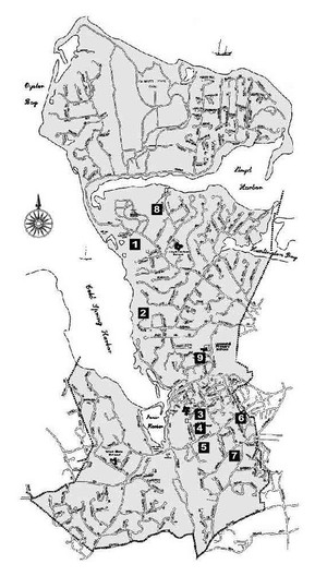
Proposed High School Property Locations
-
In 1958, two consulting firms were retained to assist in land evaluation. Four of the general requirements for an ideal site were: substantial acreage, central location, quiet and attractive location, and access to utilities. Nine different sites were considered.
In 1958, the Mahan property (#9 on the map) was recommended by Dr. Armstrong of the State Department of Education, our site committee, and our Board of Education as the first choice. Over 200 residents filed a “no” petition against the purchase of the Mahan property. They felt that it was too close to East Side School (Goosehill Primary School in 2010), and the surrounding roads were too narrow and winding for the new high school drivers.
In the early part of 1959, the combined Thicket and Hewlett (#3 and #4 on the map) properties were now the first choice.
Proposed Property Locations and Map Key:
This map displays the location of the nine properties considered for the high school.
1 Fox property
2 Jennings property
3 Thicket Heights/Edwin E. and Walter Ketay (CSHHS)
4 W. H. Hewlett property (52 acres)
5 G. Nichols property (The Nature Conservancy in 2010)
6 Squadron “C” property (82 acres). In 1955, Huntington School District #3 considered this property for their new high school but later declined.
7 Property between Saw Mill Road and Woodbury Road
8 Livingston property
9 Mahan property (27 acres)


